
Untuk paparan yang lebih optimum, anda disarankan untuk muat turun fail yang disediakan. Selamat membaca!
Baca lanjut dan muat turun
Baca lanjut dan muat turun
Untuk paparan yang lebih optimum, anda disarankan untuk muat turun fail yang disediakan. Selamat membaca!
Baca lanjut dan muat turun
Baca lanjut dan muat turun
Untuk paparan yang lebih optimum, anda disarankan untuk muat turun fail yang disediakan. Selamat membaca!
Baca lanjut dan muat turun
Baca lanjut dan muat turun
Untuk paparan yang lebih optimum, anda disarankan untuk muat turun fail yang disediakan. Selamat membaca!
Baca lanjut dan muat turun
Baca lanjut dan muat turun
Untuk paparan yang lebih optimum, anda disarankan untuk muat turun fail yang disediakan. Selamat membaca!
Baca lanjut dan muat turun
Baca lanjut dan muat turun
Untuk paparan yang lebih optimum, anda disarankan untuk muat turun fail yang disediakan. Selamat membaca!
Baca lanjut dan muat turun
Baca lanjut dan muat turun
Sila muat turun bahan untuk paparan yang lebih baik. Selamat membaca tuan/puan.
Baca lanjut dan muat turun
Baca lanjut dan muat turun
Sila muat turun bahan bacaan tersebut untuk paparan yang lebih jelas. Selamat membaca.
Baca lanjut dan muat turun
Baca lanjut dan muat turun
Sila muat turun bahan ilmiah ini untuk bacaan tuan/puan. Selamat membaca!
Baca lanjut dan muat turun
Baca lanjut dan muat turun
Sila muat turun bahan ilmiah ini untuk bacaan tuan/puan. Selamat membaca!
Baca lanjut dan muat turun
Baca lanjut dan muat turun
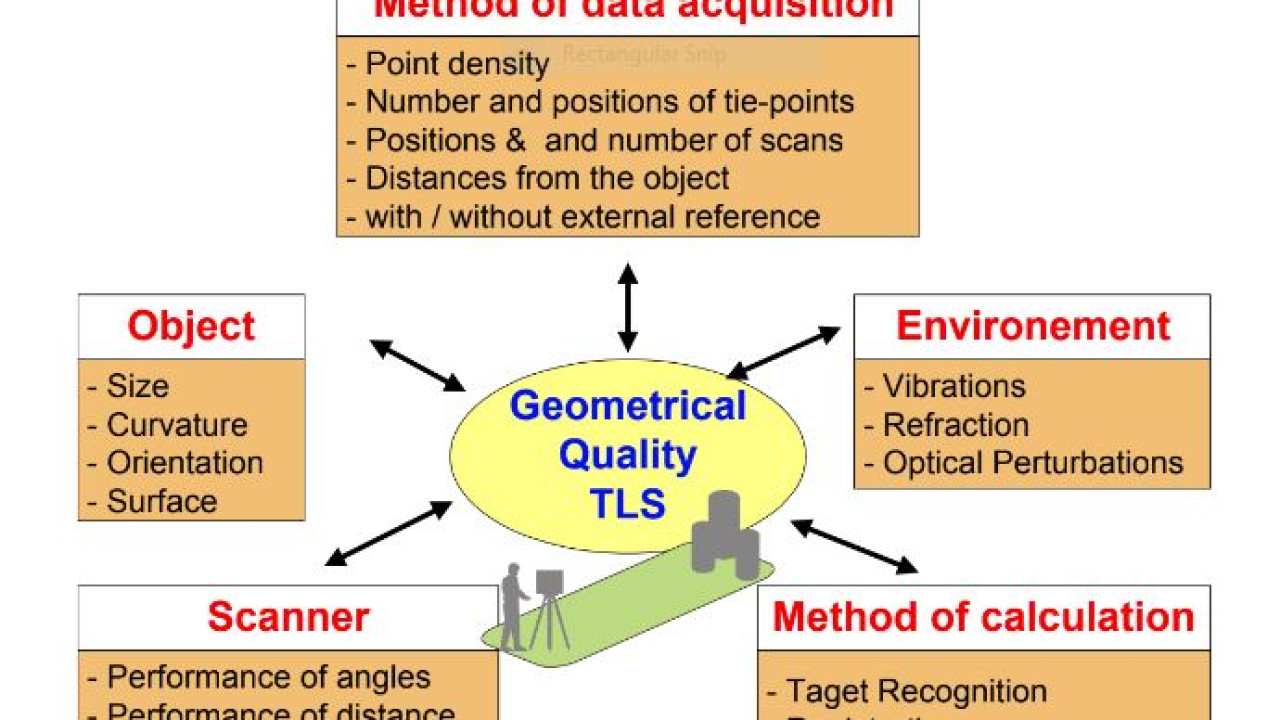
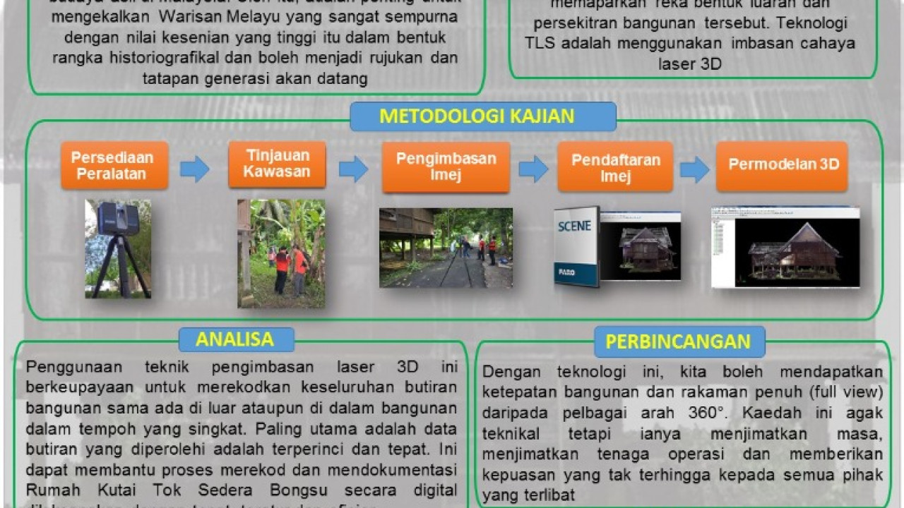
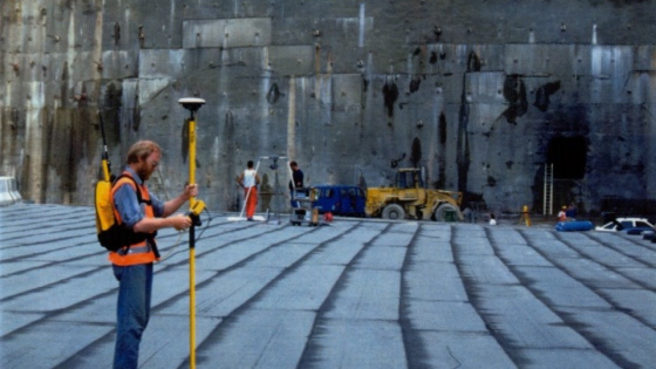
Sumber daripada The Geometrical Quality of Terrestrial Laser Scanner (TLS), Rudolf STAIGER, Germany
Baca lanjut dan muat turun
Baca lanjut dan muat turun
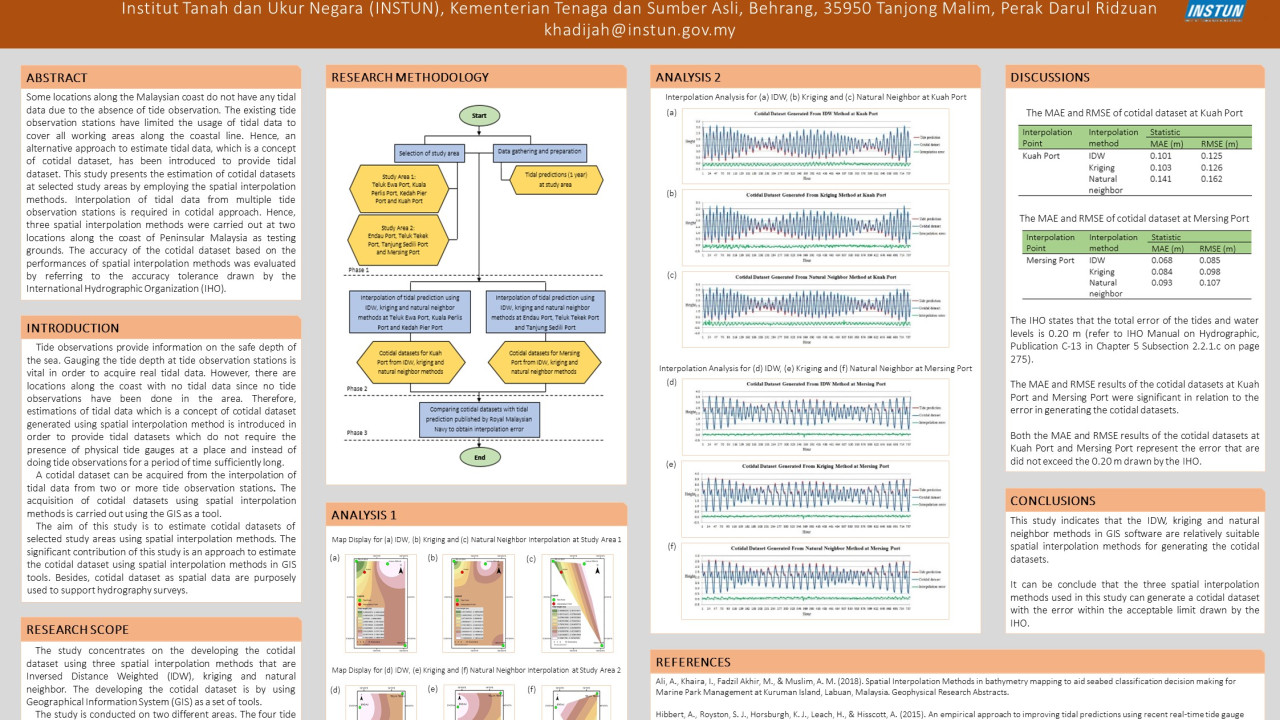
Research Poster: Generating of Cotidal Dataset by Spatial Interpolation Techniques
Baca lanjut dan muat turun
Baca lanjut dan muat turun
Balai cerap merupakan sebuah bangunan yang dibina dengan fungsi utamanya adalah sebagai pusat pencerapan objek-objek yang terdapat ruang angkasa seperti matahari, bulan, bintang, planet dan lain-lain...
Baca lanjut dan muat turun
Baca lanjut dan muat turun
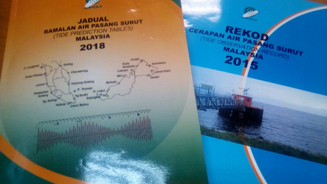
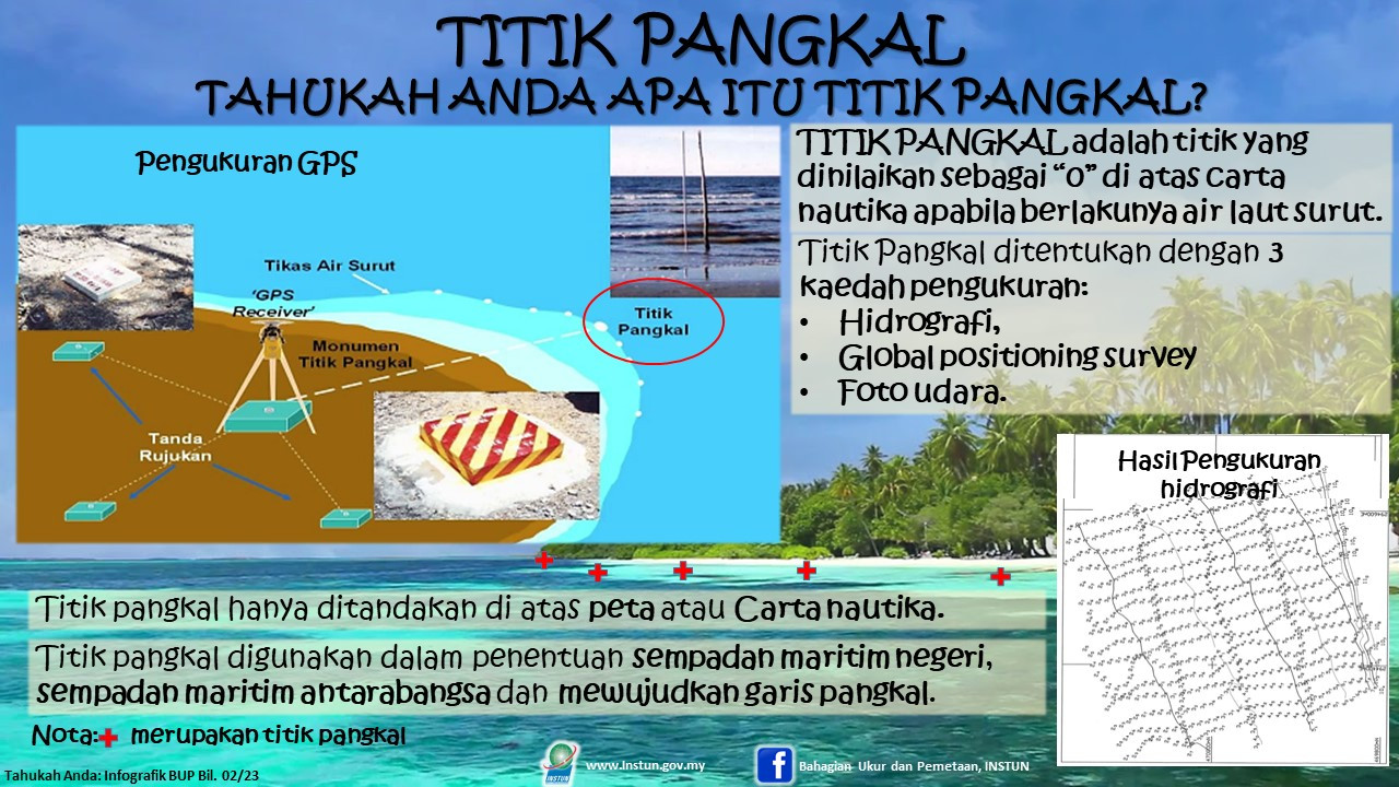
Kaedah penyimpanan dan pengumpulan data-data tertentu amat penting serta perlu terurus dan teratur bagi memudahkan proses rujukan. Hasil daripada penyimpanan data yang cekap dapat menyumbang kepada ke...
Baca lanjut dan muat turun
Baca lanjut dan muat turun
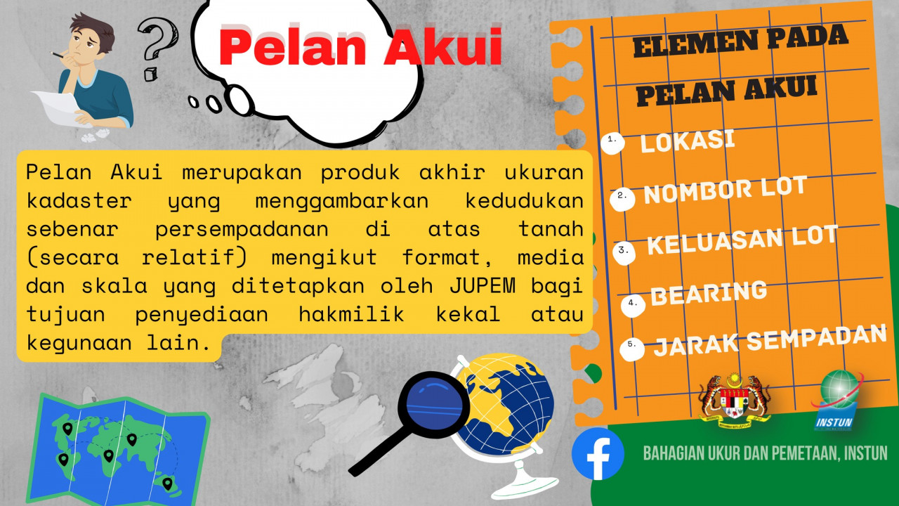
Pelan Akui (PA) bermakna pelan berkaitan tanah yang disediakan mengikut format yang telah ditentukan oleh Jabatan Ukur dan Pemetaan Malaysia (JUPEM) setelah ukuran halus dijalankan dan diluluskan oleh...
Baca lanjut dan muat turun
Baca lanjut dan muat turun
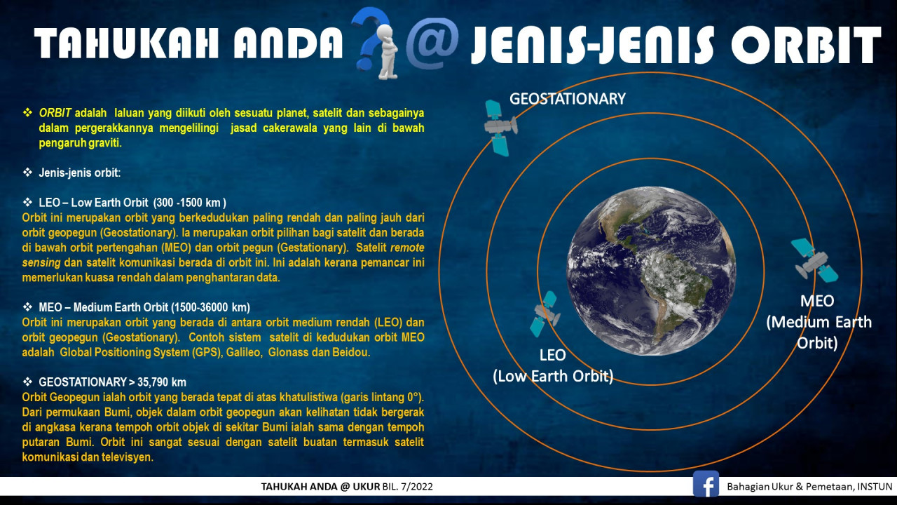
Orbit ialah satu jalan atau landasan yang dilalui oleh objek mengelilingi satu titik atau jasad, contohnya orbit sebuah planet mengelilingi sebuah bintang. Planet dan satelit mengikuti orbit eliptikal...
Baca lanjut dan muat turun
Baca lanjut dan muat turun
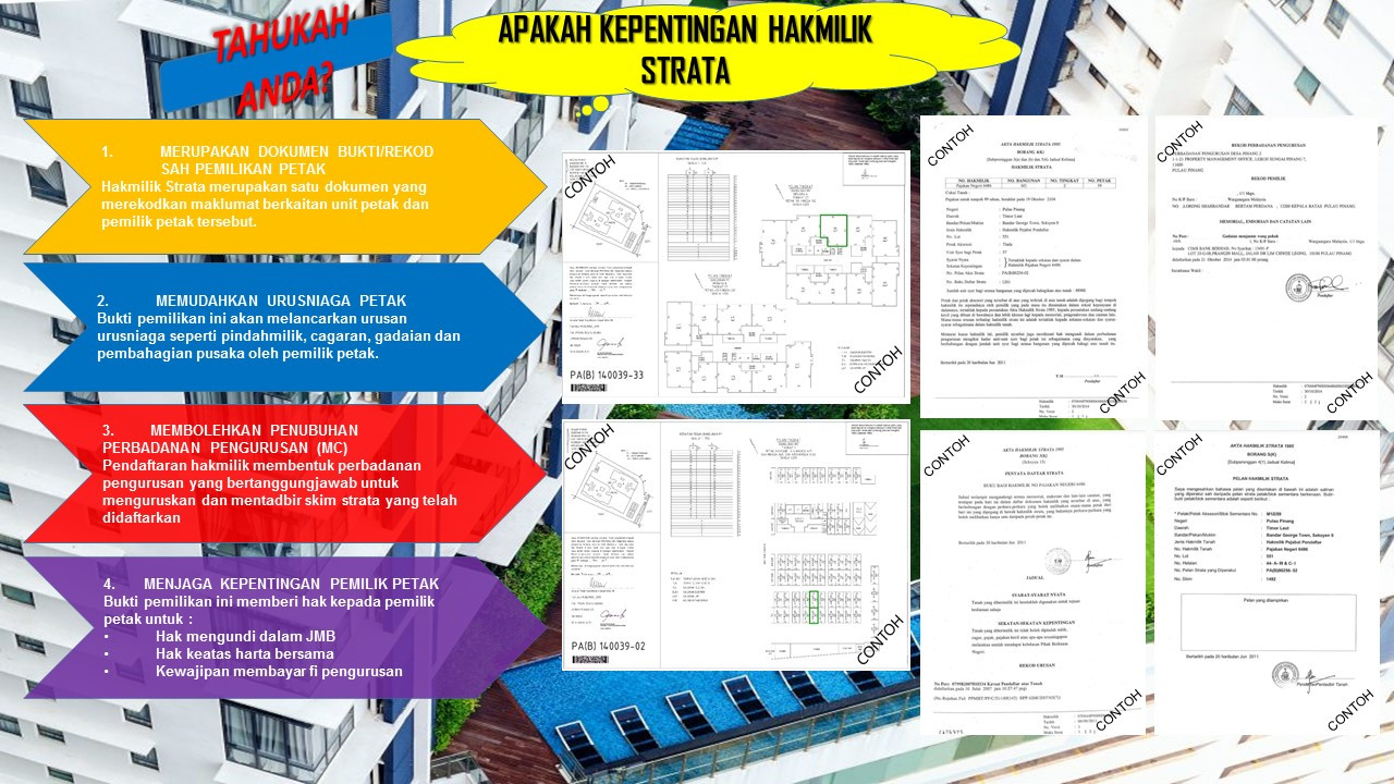
Hakmilik strata merupakan satu (1) dokumen geran yang dikeluarkan untuk pemilik unit di dalam skim strata. Antara pihak yang terlibat dalam urusan berkaitan permohonan hakmilik strata di Malaysia adal...
Baca lanjut dan muat turun
Baca lanjut dan muat turun
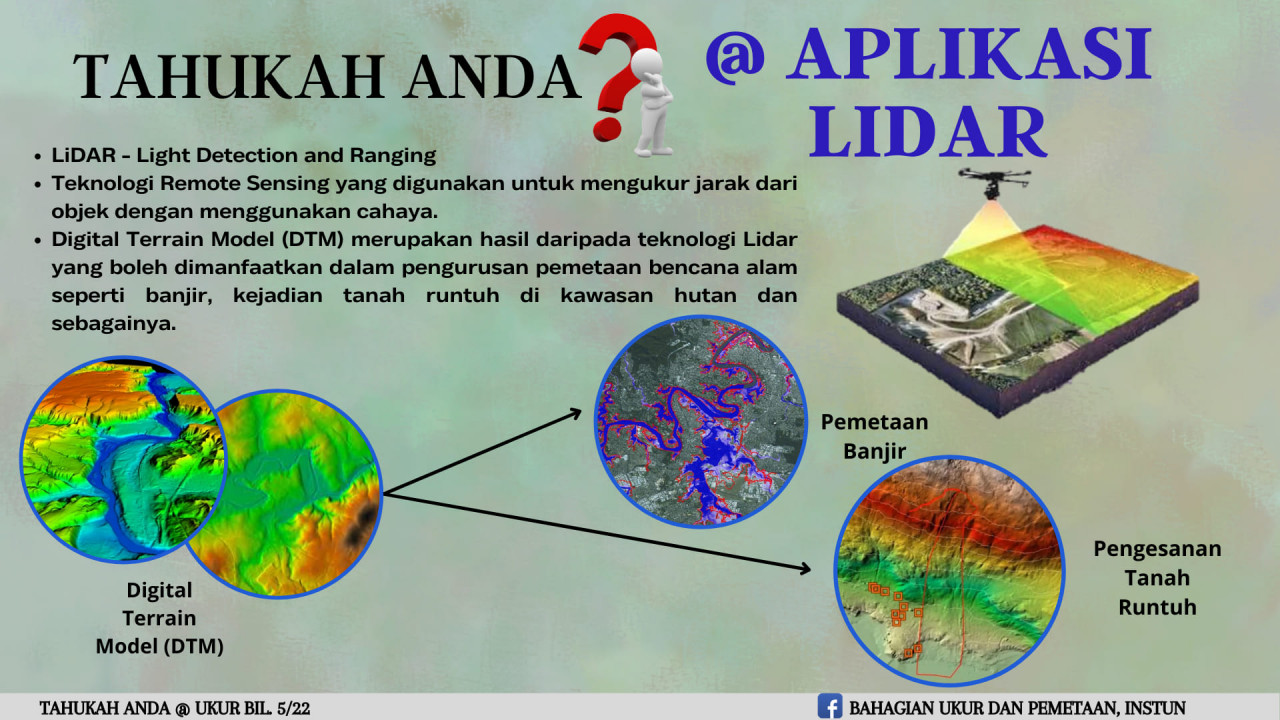
Light Detection and Ranging (LiDAR) adalah teknik penginderaan jauh (remote sensing) aktif yang menggunakan konsep talaan cahaya sasaran laser dan menganalisis cahaya pantulan. Penggunaan teknologi Li...
Baca lanjut dan muat turun
Baca lanjut dan muat turun
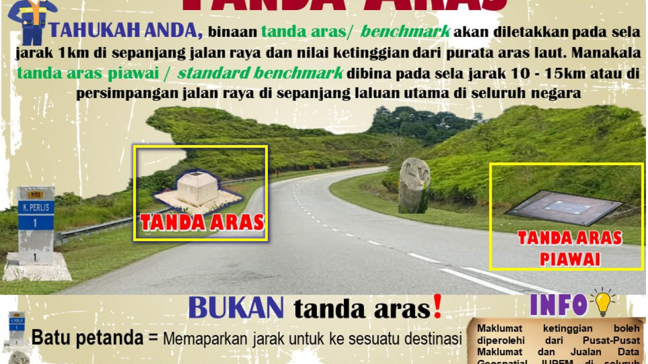
Aras dalam istilah ukur kejuruteraan adalah bermaksud maklumat ketinggian titik-titik di atas permukaan Bumi yang diperlukan dalam melaksanakan pelbagai kerja-kerja ukur kejuruteraan yang berkaitan. M...
Baca lanjut dan muat turun
Baca lanjut dan muat turun
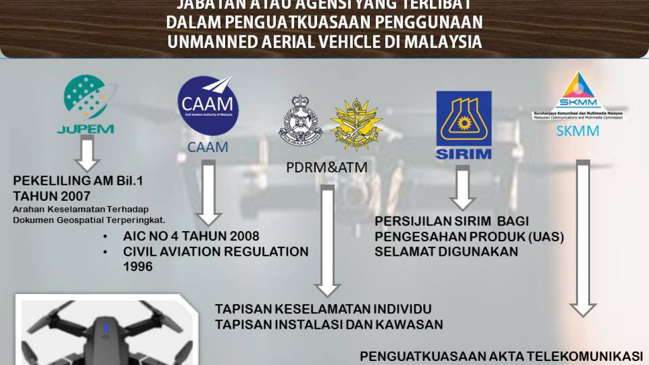
Unmanned Aerial Vehicle (UAV) atau 'Drone' merupakan pesawat kecil tanpa Juruterbang yang boleh diprogramkan untuk tujuan penerbangan. UAV berkomunikasi menggunakan radio dan Global Positioning System...
Baca lanjut dan muat turun
Baca lanjut dan muat turun
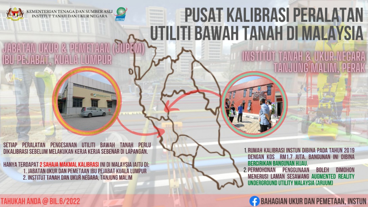
Utiliti merupakan infrastruktur asas kemudahan awam yang terdapat di bawah tanah, terdedah di atas permukaan tanah dan di atas aras tanah seperti kabel elektrik, paip air, kabel komunikasi, paip gas,...
Baca lanjut dan muat turun
Baca lanjut dan muat turun
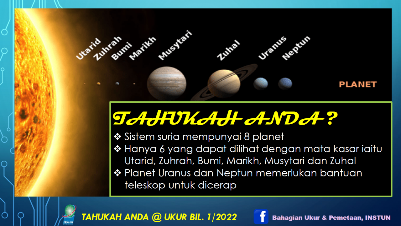
Sistem Suria kita terdiri daripada Matahari dan objek astronomi yang terikat oleh gravitinya ke dalam orbit sekelilingnya. Dari kebanyakan objek yang mengorbit Matahari, terdapat lapan ( 8 ) buah plan...
Baca lanjut dan muat turun
Baca lanjut dan muat turun
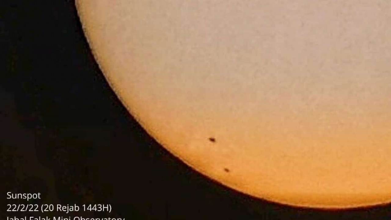
Fenomena tompok matahari ini terjadi pada permukaan luar matahari atau ‘fotosfera’ matahari dan saiznya ini juga adalah amat besar. Tompokan matahari ini kelihatan seperti satu kawasan gel...
Baca lanjut dan muat turun
Baca lanjut dan muat turun
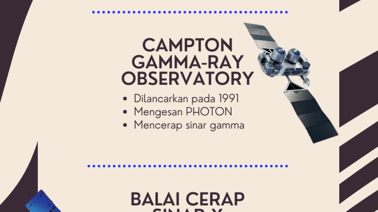
Paparan Infografik BUP bil. 8/2021 berkenaan Teleskop Angkasa. Teleskop ini berkedudukan di luar permukaan bumi. Kegunaannya bagi mendapatkan maklumat di angkasa lepas seperti teleskop Hubble yang dap...
Baca lanjut dan muat turun
Baca lanjut dan muat turun
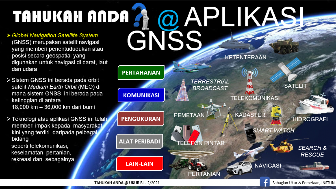
Infografik BUP bil. 2/2021 berkenaan GPS / GNSS. Ia suatu teknologi/aplikasi yang memberi impak kepada masyarakat kini. GNSS berupaya dimanfaat dalam bidang pertahanan, komunikasi, pengurusan, alat pe...
Baca lanjut dan muat turun
Baca lanjut dan muat turun
Anda pernah membaca Peta? Perasan atau tidak apabila anda membaca sebuah peta, anda melihat suatu garis halus yang menyambung titik-titik tersebut? Ada pelbagai rupa kan, ada garisan sambung menyambun...
Baca lanjut dan muat turun
Baca lanjut dan muat turun
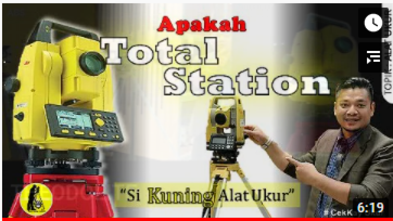
Total Station merupakan sebuah peralatan dalam menjalankan kerja pengukuran survei/ surveying job. Ia berfungsi secara digital bagi memperolehi bacaan jarak dan sudut (vertical dan horizontal) s...
Baca lanjut dan muat turun
Baca lanjut dan muat turun
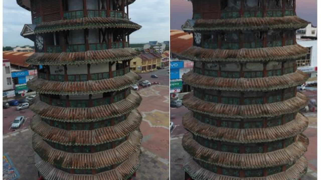
Projek penyelidikan ini adalah bertujuan untuk mengkaji keberkesanan Kaedah Penawanan Data UAV dalam penjanaan 3D Model Bangunan. Jika sebelum ini kita menggunakan ka...
Baca lanjut dan muat turun
Baca lanjut dan muat turun
Sila klik URLberikut untuk baca selanjutnyahttp://www.mygeoportal.gov.my/sites/default/files/BGSA%202019.pdf
Baca lanjut dan muat turun
Baca lanjut dan muat turun
Article regarding 3D Modelling of topographic objects by fusing 2D maps and lidar data. Therefore the data displayed will be more accurate, precise and detail.
Baca lanjut dan muat turun
Baca lanjut dan muat turun
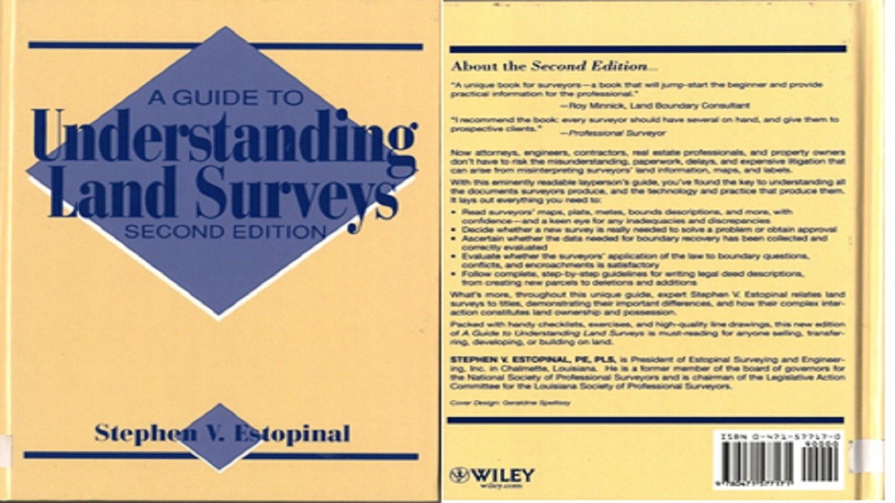
Sila dapatkan buku ini di Perpustakaan INSTUN.Bahan bacaan ini sekadar perkongsian dan tidak terikat dengah perubahan atau kaedah-kaedah semasa.
Baca lanjut dan muat turun
Baca lanjut dan muat turun

Laporan dan gambar semasa KAJIAN HILAL ZULKAEDAH 1438H oleh En.Mahruzaman (INSTUN)
Baca lanjut dan muat turun
Baca lanjut dan muat turun

Laporan dan gambar semasa KAJIAN HILAL RABIULAKHIR 1438H oleh En.Mahruzaman (INSTUN)
Baca lanjut dan muat turun
Baca lanjut dan muat turun
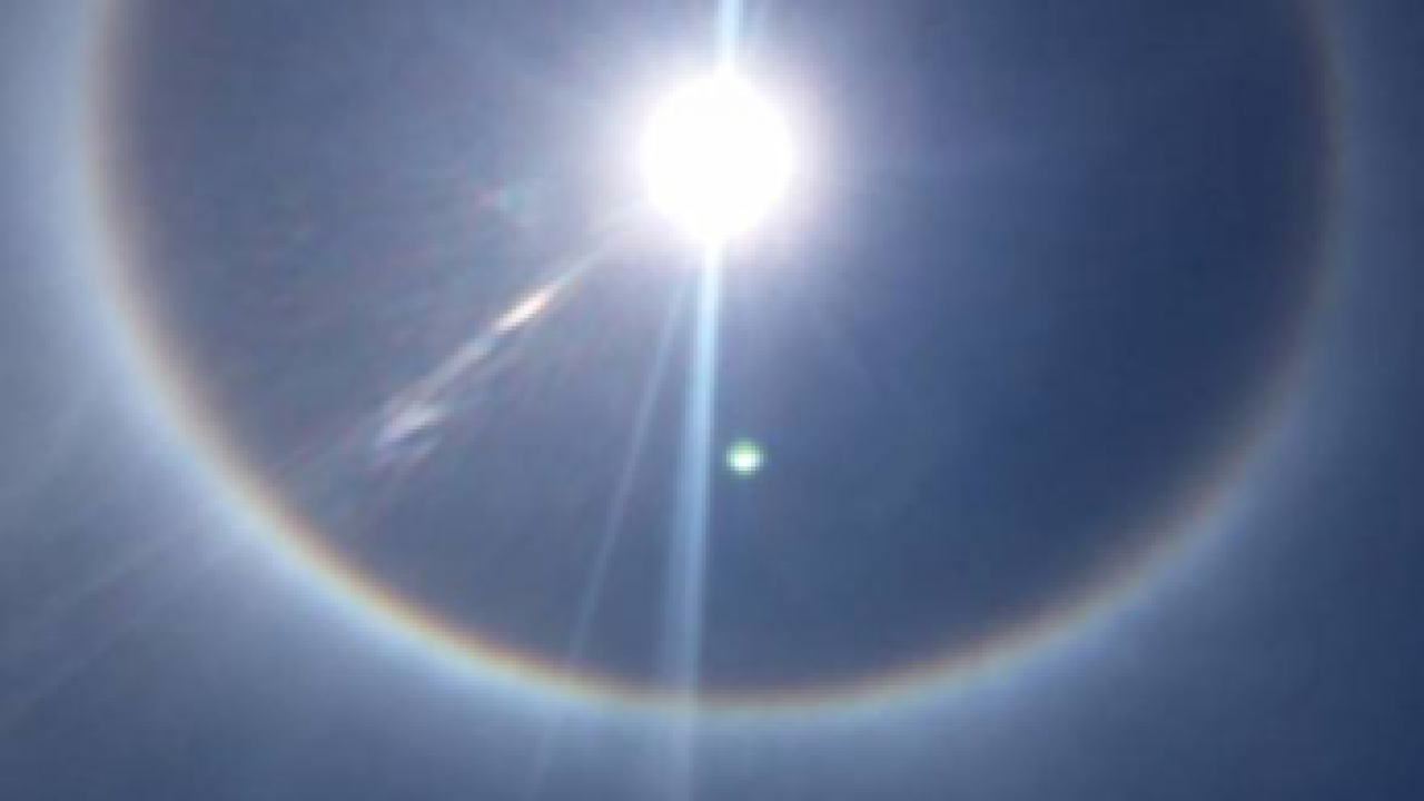
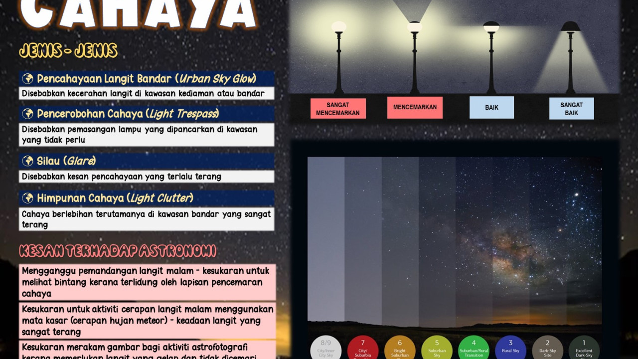
Pengenalan ringkas berkenaan Fenomena Halo (berasal dari perkataan Greek ) adalah lingkaran cahaya seakan-akan pelangi yang mengelilingi Matahari. Ia adalah sejenis fenomena optik.
Baca lanjut dan muat turun
Baca lanjut dan muat turun
Title: GPS for Land Surveyors (2nd Edition)Author: Jan Van SicklePublisher: CRC PRESSThis book is about the Global Positioning System is finding its way into the surveying and mapping field at an incr...
Baca lanjut dan muat turun
Baca lanjut dan muat turun
Sila Dapatkan Buku ini di Perpustakaan INSTUNBahan bacaan ini sekadar perkongsian dan tidak terikat dengah perubahan atau kaedah-kaedah semasa.
Baca lanjut dan muat turun
Baca lanjut dan muat turun
On the 22 of July 2009 an expedition for the Total Solar Eclipse in Hangzhou city, China, carried out by Malaysian National Eclipse Tracking Team (NETT). The task of the expedition was to do imaging a...
Baca lanjut dan muat turun
Baca lanjut dan muat turun
Antara istilah-istilah yang sering digunakan dalam GNSS atau GPS untuk rujukan
Baca lanjut dan muat turun
Baca lanjut dan muat turun
i. Digunakan untuk memindahkan ketinggian titik sekiranya ketinggian penjuru diketahui
ii. Diaplikasikan untuk mengira MyGeoid Malaysia
iii. Sela jarak bagi mygeoid adalah 30 meter arah utara dan ti...
Baca lanjut dan muat turun
Baca lanjut dan muat turun
PROGRAM GERHANA MATAHARI SEPARA
(PARTIAL SOLAR ECLIPSE)
PADA 09 MAC 2016 (29 JAMADILAWAL 1437H)
DI INSTUN, TANJONG MALIM, PERAKMahruzaman Misran
Institut Tanah dan Ukur Negara (INSTUN)
1.0 LATAR...
Baca lanjut dan muat turun
Baca lanjut dan muat turun
Sila klik pada butang DOWNLOAD PDF untuk muat turun dan membaca artikel penuh.
Baca lanjut dan muat turun
Baca lanjut dan muat turun
Sila klik pada butang DOWNLOAD PDF untuk muat turun dan membaca artikel penuh.
Baca lanjut dan muat turun
Baca lanjut dan muat turun
Sila klik pada butang DOWNLOAD PDF untuk muat turun dan membaca artikel penuh.
Baca lanjut dan muat turun
Baca lanjut dan muat turun
Sila klik pada butang DOWNLOAD PDF untuk muat turun dan membaca artikel penuh.
Baca lanjut dan muat turun
Baca lanjut dan muat turun
Sila klik pada butang DOWNLOAD PDF untuk muat turun dan membaca artikel penuh.
Baca lanjut dan muat turun
Baca lanjut dan muat turun
Sila klik pada butang DOWNLOAD PDF untuk muat turun dan membaca artikel penuh.
Baca lanjut dan muat turun
Baca lanjut dan muat turun
Sila klik pada butang DOWNLOAD PDF untuk muat turun dan membaca artikel penuh.
Baca lanjut dan muat turun
Baca lanjut dan muat turun
Sila klik pada butang DOWNLOAD PDF untuk muat turun dan membaca artikel penuh.
Baca lanjut dan muat turun
Baca lanjut dan muat turun
Sila klik pada butang DOWNLOAD PDF untuk muat turun dan membaca artikel penuh.
Baca lanjut dan muat turun
Baca lanjut dan muat turun
Sila klik pada butang DOWNLOAD PDF untuk muat turun dan membaca artikel penuh.
Baca lanjut dan muat turun
Baca lanjut dan muat turun
Sila klik pada butang DOWNLOAD PDF untuk muat turun dan membaca artikel penuh.
Baca lanjut dan muat turun
Baca lanjut dan muat turun
Sila klik pada butang DOWNLOAD PDF untuk muat turun dan membaca artikel penuh.
Baca lanjut dan muat turun
Baca lanjut dan muat turun
Sila klik pada butang DOWNLOAD PDF untuk muat turun dan membaca artikel penuh.
Baca lanjut dan muat turun
Baca lanjut dan muat turun
Sila klik pada butang DOWNLOAD PDF untuk muat turun dan membaca artikel penuh.
Baca lanjut dan muat turun
Baca lanjut dan muat turun
Sila klik pada butang DOWNLOAD PDF untuk muat turun dan membaca artikel penuh.
Baca lanjut dan muat turun
Baca lanjut dan muat turun
Sila klik pada butang DOWNLOAD PDF untuk muat turun dan membaca artikel penuh.
Baca lanjut dan muat turun
Baca lanjut dan muat turun
Sila klik pada butang DOWNLOAD PDF untuk muat turun dan membaca artikel penuh.
Baca lanjut dan muat turun
Baca lanjut dan muat turun
Sila klik pada butang DOWNLOAD PDF untuk muat turun dan membaca artikel penuh.
Baca lanjut dan muat turun
Baca lanjut dan muat turun
Sila klik pada butang DOWNLOAD PDF untuk muat turun dan membaca artikel penuh.
Baca lanjut dan muat turun
Baca lanjut dan muat turun
11 FEB 2014 Sr Roslan Abd GhaniSila klik pada butang DOWNLOAD PDF untuk muat turun dan membaca artikel penuh.
Baca lanjut dan muat turun
Baca lanjut dan muat turun
Sila klik pada butang DOWNLOAD PDF untuk muat turun dan membaca artikel penuh.
Baca lanjut dan muat turun
Baca lanjut dan muat turun
Sila klik pada butang DOWNLOAD PDF untuk muat turun dan membaca artikel penuh.
Baca lanjut dan muat turun
Baca lanjut dan muat turun
Sila klik pada butang DOWNLOAD PDF untuk muat turun dan membaca artikel penuh.
Baca lanjut dan muat turun
Baca lanjut dan muat turun
Sila klik pada butang DOWNLOAD PDF untuk muat turun dan membaca artikel penuh.
Baca lanjut dan muat turun
Baca lanjut dan muat turun
Sila klik pada butang DOWNLOAD PDF untuk muat turun dan membaca artikel penuh.
Baca lanjut dan muat turun
Baca lanjut dan muat turun
Sila klik pada butang DOWNLOAD PDF untuk muat turun dan membaca artikel penuh.
Baca lanjut dan muat turun
Baca lanjut dan muat turun
Sila klik pada butang DOWNLOAD PDF untuk muat turun dan membaca artikel penuh.
Baca lanjut dan muat turun
Baca lanjut dan muat turun
Sila klik pada butang DOWNLOAD PDF untuk muat turun dan membaca artikel penuh.
Baca lanjut dan muat turun
Baca lanjut dan muat turun
Sila klik pada butang DOWNLOAD PDF untuk muat turun dan membaca artikel penuh.
Baca lanjut dan muat turun
Baca lanjut dan muat turun
Sila klik pada butang DOWNLOAD PDF untuk muat turun dan membaca artikel penuh.
Baca lanjut dan muat turun
Baca lanjut dan muat turun
Sila klik pada butang DOWNLOAD PDF untuk muat turun dan membaca artikel penuh.
Baca lanjut dan muat turun
Baca lanjut dan muat turun
Sila klik pada butang DOWNLOAD PDF untuk muat turun dan membaca artikel penuh.
Baca lanjut dan muat turun
Baca lanjut dan muat turun
Sila klik pada butang DOWNLOAD PDF untuk muat turun dan membaca artikel penuh.
Baca lanjut dan muat turun
Baca lanjut dan muat turun
Sila klik pada butang DOWNLOAD PDF untuk muat turun dan membaca artikel penuh.
Baca lanjut dan muat turun
Baca lanjut dan muat turun
Sila klik pada butang DOWNLOAD PDF untuk muat turun dan membaca artikel penuh.
Baca lanjut dan muat turun
Baca lanjut dan muat turun
Sila klik pada butang DOWNLOAD PDF untuk muat turun dan membaca artikel penuh.
Baca lanjut dan muat turun
Baca lanjut dan muat turun
Sila klik pada butang DOWNLOAD PDF untuk muat turun dan membaca artikel penuh.
Baca lanjut dan muat turun
Baca lanjut dan muat turun
Sila klik pada butang DOWNLOAD PDF untuk muat turun dan membaca artikel penuh.
Baca lanjut dan muat turun
Baca lanjut dan muat turun
Sila klik pada butang DOWNLOAD PDF untuk muat turun dan membaca artikel penuh.
Baca lanjut dan muat turun
Baca lanjut dan muat turun
Sila klik pada butang DOWNLOAD PDF untuk muat turun dan membaca artikel penuh.
Baca lanjut dan muat turun
Baca lanjut dan muat turun
Sila klik pada butang DOWNLOAD PDF untuk muat turun dan membaca artikel penuh.
Baca lanjut dan muat turun
Baca lanjut dan muat turun
Sila klik pada butang DOWNLOAD PDF untuk muat turun dan membaca artikel penuh.
Baca lanjut dan muat turun
Baca lanjut dan muat turun
Sila klik pada butang DOWNLOAD PDF untuk muat turun dan membaca artikel penuh.
Baca lanjut dan muat turun
Baca lanjut dan muat turun
Sila klik pada butang DOWNLOAD PDF untuk muat turun dan membaca artikel penuh.
Baca lanjut dan muat turun
Baca lanjut dan muat turun
Sila klik pada butang DOWNLOAD PDF untuk muat turun dan membaca artikel penuh.
Baca lanjut dan muat turun
Baca lanjut dan muat turun
Sila klik pada butang DOWNLOAD PDF untuk muat turun dan membaca artikel penuh.
Baca lanjut dan muat turun
Baca lanjut dan muat turun
Sila klik pada butang DOWNLOAD PDF untuk muat turun dan membaca artikel penuh.
Baca lanjut dan muat turun
Baca lanjut dan muat turun
Sila klik pada butang DOWNLOAD PDF untuk muat turun dan membaca artikel penuh.
Baca lanjut dan muat turun
Baca lanjut dan muat turun
Sila klik pada butang DOWNLOAD PDF untuk muat turun dan membaca artikel penuh.
Baca lanjut dan muat turun
Baca lanjut dan muat turun
Sila klik pada butang DOWNLOAD PDF untuk muat turun dan membaca artikel penuh.
Baca lanjut dan muat turun
Baca lanjut dan muat turun
Sila klik pada butang DOWNLOAD PDF untuk muat turun dan membaca artikel penuh.
Baca lanjut dan muat turun
Baca lanjut dan muat turun
Sila klik pada butang DOWNLOAD PDF untuk muat turun dan membaca artikel penuh.
Baca lanjut dan muat turun
Baca lanjut dan muat turun
Sila klik pada butang DOWNLOAD PDF untuk muat turun dan membaca artikel penuh.
Baca lanjut dan muat turun
Baca lanjut dan muat turun
Sila klik pada butang DOWNLOAD PDF untuk muat turun dan membaca artikel penuh.
Baca lanjut dan muat turun
Baca lanjut dan muat turun
Sila klik pada butang DOWNLOAD PDF untuk muat turun dan membaca artikel penuh.
Baca lanjut dan muat turun
Baca lanjut dan muat turun
Sila klik pada butang DOWNLOAD PDF untuk muat turun dan membaca artikel penuh.
Baca lanjut dan muat turun
Baca lanjut dan muat turun
Sila klik pada butang DOWNLOAD PDF untuk muat turun dan membaca artikel penuh.
Baca lanjut dan muat turun
Baca lanjut dan muat turun
Sila klik pada butang DOWNLOAD PDF untuk muat turun dan membaca artikel penuh.
Baca lanjut dan muat turun
Baca lanjut dan muat turun
Sila klik pada butang DOWNLOAD PDF untuk muat turun dan membaca artikel penuh.
Baca lanjut dan muat turun
Baca lanjut dan muat turun
Sila klik pada butang DOWNLOAD PDF untuk muat turun dan membaca artikel penuh.
Baca lanjut dan muat turun
Baca lanjut dan muat turun
Sila klik pada butang DOWNLOAD PDF untuk muat turun dan membaca artikel penuh.
Baca lanjut dan muat turun
Baca lanjut dan muat turun
Sila klik pada butang DOWNLOAD PDF untuk muat turun dan membaca artikel penuh.
Baca lanjut dan muat turun
Baca lanjut dan muat turun
Sila klik pada butang DOWNLOAD PDF untuk muat turun dan membaca artikel penuh.
Baca lanjut dan muat turun
Baca lanjut dan muat turun
Sila klik pada butang DOWNLOAD PDF untuk muat turun dan membaca artikel penuh.
Baca lanjut dan muat turun
Baca lanjut dan muat turun
Sila klik pada butang DOWNLOAD PDF untuk muat turun dan membaca artikel penuh.
Baca lanjut dan muat turun
Baca lanjut dan muat turun
Sila klik pada butang DOWNLOAD PDF untuk muat turun dan membaca artikel penuh.
Baca lanjut dan muat turun
Baca lanjut dan muat turun
Sila klik pada butang DOWNLOAD PDF untuk muat turun dan membaca artikel penuh.
Baca lanjut dan muat turun
Baca lanjut dan muat turun
Sila klik pada butang DOWNLOAD PDF untuk muat turun dan membaca artikel penuh.
Baca lanjut dan muat turun
Baca lanjut dan muat turun
Sila klik pada butang DOWNLOAD PDF untuk muat turun dan membaca artikel penuh.
Baca lanjut dan muat turun
Baca lanjut dan muat turun
Sila klik pada butang DOWNLOAD PDF untuk muat turun dan membaca artikel penuh.
Baca lanjut dan muat turun
Baca lanjut dan muat turun
Sila klik pada butang DOWNLOAD PDF untuk muat turun dan membaca artikel penuh.
Baca lanjut dan muat turun
Baca lanjut dan muat turun
Sila klik pada butang DOWNLOAD PDF untuk muat turun dan membaca artikel penuh.
Baca lanjut dan muat turun
Baca lanjut dan muat turun
Sila klik pada butang DOWNLOAD PDF untuk muat turun dan membaca artikel penuh.
Baca lanjut dan muat turun
Baca lanjut dan muat turun
Sila klik pada butang DOWNLOAD PDF untuk muat turun dan membaca artikel penuh.
Baca lanjut dan muat turun
Baca lanjut dan muat turun
Sila klik pada butang DOWNLOAD PDF untuk muat turun dan membaca artikel penuh.
Baca lanjut dan muat turun
Baca lanjut dan muat turun
Sila klik pada butang DOWNLOAD PDF untuk muat turun dan membaca artikel penuh.
Baca lanjut dan muat turun
Baca lanjut dan muat turun
Sila klik pada butang DOWNLOAD PDF untuk muat turun dan membaca artikel penuh.
Baca lanjut dan muat turun
Baca lanjut dan muat turun
Sila klik pada butang DOWNLOAD PDF untuk muat turun dan membaca artikel penuh.
Baca lanjut dan muat turun
Baca lanjut dan muat turun
Sila klik pada butang DOWNLOAD PDF untuk muat turun dan membaca artikel penuh.
Baca lanjut dan muat turun
Baca lanjut dan muat turun
Sila klik pada butang DOWNLOAD PDF untuk muat turun dan membaca artikel penuh.
Baca lanjut dan muat turun
Baca lanjut dan muat turun
Sila klik pada butang DOWNLOAD PDF untuk muat turun dan membaca artikel penuh.
Baca lanjut dan muat turun
Baca lanjut dan muat turun
Sila klik pada butang DOWNLOAD PDF untuk muat turun dan membaca artikel penuh.
Baca lanjut dan muat turun
Baca lanjut dan muat turun
Sila klik pada butang DOWNLOAD PDF untuk muat turun dan membaca artikel penuh.
Baca lanjut dan muat turun
Baca lanjut dan muat turun
Sila klik pada butang DOWNLOAD PDF untuk muat turun dan membaca artikel penuh.
Baca lanjut dan muat turun
Baca lanjut dan muat turun
Sila klik pada butang DOWNLOAD PDF untuk muat turun dan membaca artikel penuh.
Baca lanjut dan muat turun
Baca lanjut dan muat turun
Sila klik pada butang DOWNLOAD PDF untuk muat turun dan membaca artikel penuh.
Baca lanjut dan muat turun
Baca lanjut dan muat turun
Sila klik pada butang DOWNLOAD PDF untuk muat turun dan membaca artikel penuh.
Baca lanjut dan muat turun
Baca lanjut dan muat turun
Sila klik pada butang DOWNLOAD PDF untuk muat turun dan membaca artikel penuh.
Baca lanjut dan muat turun
Baca lanjut dan muat turun
Sila klik pada butang DOWNLOAD PDF untuk muat turun dan membaca artikel penuh.
Baca lanjut dan muat turun
Baca lanjut dan muat turun
Sila klik pada butang DOWNLOAD PDF untuk muat turun dan membaca artikel penuh.
Baca lanjut dan muat turun
Baca lanjut dan muat turun
Sila klik pada butang DOWNLOAD PDF untuk muat turun dan membaca artikel penuh.
Baca lanjut dan muat turun
Baca lanjut dan muat turun
Sila klik pada butang DOWNLOAD PDF untuk muat turun dan membaca artikel penuh.
Baca lanjut dan muat turun
Baca lanjut dan muat turun
Sila klik pada butang DOWNLOAD PDF untuk muat turun dan membaca artikel penuh.
Baca lanjut dan muat turun
Baca lanjut dan muat turun
Jørgen SKRUBBELTRANG, DenmarkSUMMARY
The Danish government wants both to ease the process of buying and selling properties and to
reduce associated costs. The DIADEM project was one of...
Baca lanjut dan muat turun
Baca lanjut dan muat turun
Ahmet YILMAZ and Hülya DEMİR, TURKEYSUMMARY
Land readjustment (LR) is an important technique used in a variety of countries to realize the
development plans by converting ru...
Baca lanjut dan muat turun
Baca lanjut dan muat turun
Robin MCLAREN, UKSUMMARY
The pressure to change and provide more appropriate and efficient land administration
services and strengthen security of tenure is growing within global political circles....
Baca lanjut dan muat turun
Baca lanjut dan muat turun
SR AHAMAD BIN ZAKARIA
Pengarah Ukur dan Pemetaan SelangorLATAR BELAKANG
Akta Hakmilik Strata 1985 (AHS) mula berkuatkuasa
pada 1 Jun 1985 menggantikan peruntukan 151-157
dalam Kanun Tanah Negara (...
Baca lanjut dan muat turun
Baca lanjut dan muat turun
Hassan CHTOUKI, MoroccoSUMMARY
Urbanization of urban and suburban areas results mainly from population growth, emigration
and the spatial redeployment. It is often accompanied by precarious habitat,...
Baca lanjut dan muat turun
Baca lanjut dan muat turun
AC-Chukwuocha, Ngozi BlessingABSTRACT
Otamiri watershed in Owerri, South East Nigeria is an urban watershed that is faced with
serious ecological stresses due to intense land-use conversion. Siltati...
Baca lanjut dan muat turun
Baca lanjut dan muat turun
Xhevdet SHALA, Murat MEHA and
Sulejman AHMEDI, Kosovo SUMMARY
The Kosovo Cadastral Agency (KCA) is regulated through UNMIK Regulationi
and by the
Law on the Establishment of the Immovable Propert...
Baca lanjut dan muat turun
Baca lanjut dan muat turun
Zeynel Abidin POLAT, Mustafa USTUNER and Mehmet ALKAN, TurkeySUMMARY
The International Federation of Surveyors (FIG)'s 7th Commission which deals with the
subjects of Cadastre and Land Management de...
Baca lanjut dan muat turun
Baca lanjut dan muat turun
Sila klik pada butang DOWNLOAD PDF untuk muat turun dan membaca artikel penuh.
Baca lanjut dan muat turun
Baca lanjut dan muat turun
Sila klik pada butang DOWNLOAD PDF untuk muat turun dan membaca artikel penuh.
Baca lanjut dan muat turun
Baca lanjut dan muat turun
Sila klik pada butang DOWNLOAD PDF untuk muat turun dan membaca artikel penuh.
Baca lanjut dan muat turun
Baca lanjut dan muat turun
Sila klik pada butang DOWNLOAD PDF untuk muat turun dan membaca artikel penuh.
Baca lanjut dan muat turun
Baca lanjut dan muat turun
Sila klik pada butang DOWNLOAD PDF untuk muat turun dan membaca artikel penuh.
Baca lanjut dan muat turun
Baca lanjut dan muat turun
Sila klik pada butang DOWNLOAD PDF untuk muat turun dan membaca artikel penuh.
Baca lanjut dan muat turun
Baca lanjut dan muat turun
Sila klik pada butang DOWNLOAD PDF untuk muat turun dan membaca artikel penuh.
Baca lanjut dan muat turun
Baca lanjut dan muat turun
A. Country Context
Geographic Context
The People’s Republic of China, located in East Asia, on the western shore of the Pacific
Ocean, is the third largest country in the world in...
Baca lanjut dan muat turun
Baca lanjut dan muat turun
A. Country Context
Geographical Context
Cyprus is situated in the north-eastern part of the Mediterranean Sea, with an area of 9251 km²
and a population of approximately 793,000. Topogr...
Baca lanjut dan muat turun
Baca lanjut dan muat turun
Sila klik pada butang DOWNLOAD PDF untuk muat turun dan membaca artikel penuh.
Baca lanjut dan muat turun
Baca lanjut dan muat turun
Sila klik pada butang DOWNLOAD PDF untuk muat turun dan membaca artikel penuh.
Baca lanjut dan muat turun
Baca lanjut dan muat turun
Sila klik pada butang DOWNLOAD PDF untuk muat turun dan membaca artikel penuh.
Baca lanjut dan muat turun
Baca lanjut dan muat turun
A. Country Context
Geographical Context
Finland has 5.3 million inhabitants. The total area of the country is 338,000 km2
. On average
there are about 17 inhabitants/km2
. The population is locat...
Baca lanjut dan muat turun
Baca lanjut dan muat turun
A. Country Context
Geographical Context
The Federal Republic of Germany is situated in the heart of Europe with nine neighbor countries.
Germany is a link between East and West and between Scandina...
Baca lanjut dan muat turun
Baca lanjut dan muat turun
A. Country ContextGeographical Context
Hong Kong, geologically a submerged highland area, is a deepwater port in Southeast China,
with an area about 1100 km2. Most of the 6.8 million of population d...
Baca lanjut dan muat turun
Baca lanjut dan muat turun
Sila klik pada butang DOWNLOAD PDF untuk muat turun dan membaca artikel penuh.
Baca lanjut dan muat turun
Baca lanjut dan muat turun
A. Country Context
Geographical Context
India is located in Southern Asia, bordering the Arabian Sea and Bay of Bengal, between Burma
and Pakistan with an area of over 3,287,270 sq km including ter...
Baca lanjut dan muat turun
Baca lanjut dan muat turun
A. Country Context
Geographical Context
Indonesia is the largest archipelagic country in the world, consists of 17,508 small and big islands,
with a total area of 1,919,440 sq km, consists of water...
Baca lanjut dan muat turun
Baca lanjut dan muat turun
A. Country Context
Geographical Context
Iran is the large country in Middle East, with a total area of 1,648,195 sq km, lying south of Armenia,
Azerbaijan, Turkmenistan, and nourth of Qatar, U.A.E,...
Baca lanjut dan muat turun
Baca lanjut dan muat turun
A. Country Context
Geographical Context
Japan is an island nation stretching archwise in northeastern Asia between the North Pacific
and the Sea of Japan. The land consists of 4 main islands and ov...
Baca lanjut dan muat turun
Baca lanjut dan muat turun
A. Country Context
Geographical Context
Jordan‘s total area is around 89,000km2 and with a population of about 5 millions inhabitants.
The Capital city of Jordan is Amman with pop...
Baca lanjut dan muat turun
Baca lanjut dan muat turun
Sila klik pada butang DOWNLOAD PDF untuk muat turun dan membaca artikel penuh.
Baca lanjut dan muat turun
Baca lanjut dan muat turun
Sila klik pada butang DOWNLOAD PDF untuk muat turun dan membaca artikel penuh.
Baca lanjut dan muat turun
Baca lanjut dan muat turun
A. Country Context
Geographical Context
The Macao Special Administrative Region (MSAR), being part of the China Territory, is located
at the Pearl River Delta of the southeastern coast of Mainland...
Baca lanjut dan muat turun
Baca lanjut dan muat turun
A. Country Context
Geographical Context
The Republic of Turkey is located at a point where the three continents making up the old world.
Geographically, the country is located in the northern half...
Baca lanjut dan muat turun
Baca lanjut dan muat turun
A. Country Context
Geographical Context
Uzbekistan, one of the Central Asian States lies in the heart of Asia, in the territory known since
ancient times as Bactria, Maverannahr, and later on as Tu...
Baca lanjut dan muat turun
Baca lanjut dan muat turun
Sila klik pada butang DOWNLOAD PDF untuk muat turun dan membaca artikel penuh.
Baca lanjut dan muat turun
Baca lanjut dan muat turun
A. Country Context
Geographical Context
Malaysia covers an area of about 329,758 sq. km, consisting of 11 states in Peninsular Malaysia,
2 states in the island of Borneo (Sabah and Sarawak) and 3 F...
Baca lanjut dan muat turun
Baca lanjut dan muat turun
Sila klik pada butang DOWNLOAD PDF untuk muat turun dan membaca artikel penuh.
Baca lanjut dan muat turun
Baca lanjut dan muat turun
N. R. HANIFA, E. DJUNARSJAH and K. WIKANTIKA, IndonesiaSUMMARY
State boundaries are the main manifestation of a country sovereignty. Up to now, Indonesia
has still unresolved its maritime boundary w...
Baca lanjut dan muat turun
Baca lanjut dan muat turun
Sila klik pada butang DOWNLOAD PDF untuk muat turun dan membaca artikel penuh.
Baca lanjut dan muat turun
Baca lanjut dan muat turun
ABSTRACT
This paper discusses the various reforms impacting on the NZ Cadastral survey system.
Recent and proposed initiatives to develop the cadastre to meet growing needs for more
effective land...
Baca lanjut dan muat turun
Baca lanjut dan muat turun
Dr. Adib FARES, LebanonABSTRACT
In this paper, we compared the Lebanese Cadastral System with that of the German,
Australian, Canadian, French, and English Systems. The current Lebanese Cadastral Sy...
Baca lanjut dan muat turun
Baca lanjut dan muat turun
Keith C. BELL, Surveyor General of Victoria
and
Mark CLEARY, Project Officer, Survey Reform
Department of Natural Resources and Environment, Victoria ABSTRACT
Land Surveying is not an exact s...
Baca lanjut dan muat turun
Baca lanjut dan muat turun
History
The Study Group on the Coordinate Based Cadastre was established by the Alberta Land
Surveyors Association as a result of a motion at the 1996 AGM to strike a committee “to...
Baca lanjut dan muat turun
Baca lanjut dan muat turun
M.H.Elfick.
Dept. Civil Engineering and Surveying
University of Newcastle, Australia INTRODUCTION
The cadastral system in Australia and New Zealand evolved at a time when it was relatively...
Baca lanjut dan muat turun
Baca lanjut dan muat turun
Sila klik pada butang DOWNLOAD PDF untuk muat turun dan membaca artikel penuh.
Baca lanjut dan muat turun
Baca lanjut dan muat turun
Rita SEWORNU, Ghana and Michael BARRY, CanadaSUMMARY
Drawing on the case of the systematic land titling project piloted in Dansoman, a suburb of
Accra, Ghana, this paper investigates why and how lan...
Baca lanjut dan muat turun
Baca lanjut dan muat turun
A. Country Context
Geographical Context
Nepal is a land locked country surrounded by China in North and India in South, East and West.
The elevation ranges almost from 60m to 8848m, the highest pea...
Baca lanjut dan muat turun
Baca lanjut dan muat turun
A. Country Context
Geographical Context
The Netherlands is a country located in Western Europe, bordering the North Sea, between
Belgium and Germany. It is located at the delta of three major Europ...
Baca lanjut dan muat turun
Baca lanjut dan muat turun
A. Country Context
Geographical Context
New Zealand is situated in the Southwest Pacific (Te Moana Nui a Kiwa) ocean, some 2000 km
east of Australia in temperate latitudes, and lies close to the 18...
Baca lanjut dan muat turun
Baca lanjut dan muat turun
Li TAN, Haiyang Wu, Ming Luo, Xiaolong Tao , Jing Wang, China SUMMARY
Over the years, many Chinese provinces have implemented land consolidation
and rehabilitation and land readjustment under t...
Baca lanjut dan muat turun
Baca lanjut dan muat turun
Monika MALETA, Beata CALKA and Elzbieta BIELECKA, Poland SUMMARY
Transaction prices of land property are influenced by a number of factors that also affect the
attractiveness of the market area...
Baca lanjut dan muat turun
Baca lanjut dan muat turun
A. Country Context
Geographical Context
Norway covers the western and northern sections of the Scandinavian peninsula, and includes
the northern territories of Jan Mayen Island and the Svalbard arc...
Baca lanjut dan muat turun
Baca lanjut dan muat turun
A.Country ContextGeographical Context
Philippines is one of the South East Asian countries, composed of around 7,100 islands with a
land area of approximately 30 Million hectares and lying north of...
Baca lanjut dan muat turun
Baca lanjut dan muat turun
A. Country Context
Geographical Context
Based on statistics, emanating from Census 2001, dated October 2001, the 2nd Census in a
democratic South Africa, the estimated population of South Africa is...
Baca lanjut dan muat turun
Baca lanjut dan muat turun
Henning ELMSTRØM and Torben JUULSAGER, DenmarkSUMMARY
The Surveying profession is regulated in many countries in the European Union (EU). The
regulation is in particular distinctly in r...
Baca lanjut dan muat turun
Baca lanjut dan muat turun
Alexander RÃœGAMER, Fraunhofer IIS, Germany
Dirk KOWALEWSKI, NavXperience GmbH, Germany SUMMARY
GNSS technology is used for many applications: The surveying industry uses GNSS for...
Baca lanjut dan muat turun
Baca lanjut dan muat turun
A. Country Context
Geographical Context
Sri Lanka is a topical island, lies southeast of the Southern tip of India, and well known to travellers
of many nationalities from ancient times. Total area...
Baca lanjut dan muat turun
Baca lanjut dan muat turun
Alick R MWANZA, Zambia 1. INTRODUCTION
Since 1992 when the world’s governments realised the need to protect the environment,
sustainable development was adopted as a general p...
Baca lanjut dan muat turun
Baca lanjut dan muat turun
Stig ENEMARK, DenmarkSUMMARY
This paper argues that the fit-for-purpose approach to building land administration systems in
less developed countries will enable provision of the basic administrative...
Baca lanjut dan muat turun
Baca lanjut dan muat turun
A. Country ContextGeographical Context
Sweden has about 450,000 km2 and a population close to 9 million. About 80% live in urban areas.Sila klik pada butang DOWNLOAD PDF untuk muat turun dan membaca...
Baca lanjut dan muat turun
Baca lanjut dan muat turun
A. Country Context
Geographical Context
Switzerland is situated in the centre of Western Europe, bordering with Germany, Austria, Liechtenstein,
Italy and France. Its territory covers an area of 41...
Baca lanjut dan muat turun
Baca lanjut dan muat turun
Mohd Yunus MOHD YUSOFF, Hasan JAMIL, Nur Zurairah ABDUL HALIM,
Nor Ashikin MOHAMED YUSOF and Mohammad Azmi MOHD ZAIN, MalaysiaSUMMARY
Malaysia has moved leap and fold from her original states of old...
Baca lanjut dan muat turun
Baca lanjut dan muat turun
M Tony S HAROEN, Embun SARI, Kalvin SEMBIRING, BUDIYONO and
Ketut Ari SUCAYA, Indonesia SUMMARY
The Spirit of the road towards the development of an SDI (Spatial Data Infrastructure) is now
un...
Baca lanjut dan muat turun
Baca lanjut dan muat turun
Jennifer WHITTAL, South Africa and Michael BARRY, Canada SUMMARY
The City of Cape Town has recently implemented Computer Assisted Mass Appraisal
(CAMA) for the purposes of generating market val...
Baca lanjut dan muat turun
Baca lanjut dan muat turun
Ciprian SAVOIU, Romania,
Christian LEMMEN, The Netherlands and Ionut SAVOIU, Romania SUMMARY
The objective of this paper is to reintroduce the possibility or at least open a debate for land
co...
Baca lanjut dan muat turun
Baca lanjut dan muat turun
Habtemicael WELDEGIORGIS, EritreaSUMMARY
In Eritrea the economy is on the main agrarian and land is the basic resource for its overall
development. Land tenure in Eritrea, as in many other African c...
Baca lanjut dan muat turun
Baca lanjut dan muat turun
Robin MCLAREN, UKSUMMARY
The pressure to change and provide more appropriate and efficient land administration
services and strengthen security of tenure is growing within global political circles....
Baca lanjut dan muat turun
Baca lanjut dan muat turun
Realistic Uncertainty Estimation of the Market Value Based on a FuzzyBayesian
Sales Comparison Approach SUMMARY
The real estate and finance crisis has shown the importance of real estate valua...
Baca lanjut dan muat turun
Baca lanjut dan muat turun
Marija JURIC and Karl HAFSTRÖM MAGNÉRUS, SwedenSUMMARY
The Swedish environmental legislation plays an important part in the national environmental
efforts, and is stated in...
Baca lanjut dan muat turun
Baca lanjut dan muat turun
Memby Untung PRATAMA, Budi Jaya SILALAHI, Setyo ANGGRAINI and Yanti Cahyati
S. PRAWIRA, Indonesia In land use policy, there is an evaluation tool called Strategic Environmental Assessment
(SEA)...
Baca lanjut dan muat turun
Baca lanjut dan muat turun
TuÄŸba GÃœNEÅž and Ãœmit YILDIZ, TurkeySUMMARY
This is a summary on the paper on mass valuation techniques used in Property Valuation
component of Land R...
Baca lanjut dan muat turun
Baca lanjut dan muat turun
João HESPANHA, Portugal; Silvane PAIXÃO, Brazil; Tarun GHAWANA, India;
Jaap ZEVENBERGEN, The Netherlands; Andrea F.T. CARNEIRO, Brazil SUMMARY
Given the ever growing...
Baca lanjut dan muat turun
Baca lanjut dan muat turun
Ekrem SARALIOGLU, Deniz YILDIRIM and Oguz GUNGORSUMMARY
Turkey is the largest hazelnut producer and exporter in the world with approximately 79% of
worldwide production. Turkey also takes the fifth...
Baca lanjut dan muat turun
Baca lanjut dan muat turun
FABIAN THIEL, GermanySUMMARY
Due to a change in national legislation in 2002 (“Law on legalizing of professional sexworkers”),
professional nightclub labor is mov...
Baca lanjut dan muat turun
Baca lanjut dan muat turun
Yavor CHAPANOV, Mila ATANASOVA, Bulgaria SUMMARY
The modern geodetic observations, based on high-accuracy space techniques, provide decadal
time series of station coordinates. These time series...
Baca lanjut dan muat turun
Baca lanjut dan muat turun
Françoise DUQUENNE, Alain COULOMB et François L'ECU, France SUMMARY
IGN (French Geographical Institute or Institut national de l’information gÃ...
Baca lanjut dan muat turun
Baca lanjut dan muat turun
Daniel ROMAN, U.S.A.SUMMARY
Use of GNSS-accessed geospatial data has proliferated not only within the surveying
community but also into many related and dependent fields of work. These requirements...
Baca lanjut dan muat turun
Baca lanjut dan muat turun
SUMMARY
This is a summary on the present state of geodetic activities carried out at the General
Commission for Survey (GCS), Saudi Arabia. General Commission for Survey has the
responsibility of d...
Baca lanjut dan muat turun
Baca lanjut dan muat turun
SUMMARY
Measurements of horizontal and vertical displacements are carried out mostly based on
reference points identified as fixed. In surveying practice there may be some situations in
which there...
Baca lanjut dan muat turun
Baca lanjut dan muat turun
ABTSRACT
In the recent years the usage of state of the art monitoring systems marks a rapid progress
especially in engineering area, for the purposes of the local administration authorities and
inf...
Baca lanjut dan muat turun
Baca lanjut dan muat turun
SUMMARY
Floods are among the most devastating natural disasters in the world, claiming more lives and
causing more property damage than anyone would imagine. In Nigeria, though not leading in
terms...
Baca lanjut dan muat turun
Baca lanjut dan muat turun
SUMMARY
This study focuses on the Black Sea coast vulnerability. For this purpose, present-day sea
level changes in the Black Sea are estimated from satellite altimetry data. The result shows
accel...
Baca lanjut dan muat turun
Baca lanjut dan muat turun
SUMMARY
Over the years, hydrographic surveyors have used lead lines, sounding pole, wire drag and
sounding machine to collect the bathymetry data. To date, the vessel-based echo sounding
surveys su...
Baca lanjut dan muat turun
Baca lanjut dan muat turun
SUMMARY
Indonesia is a maritime continent with a complex and active tectonic setting and therefore
prone to various natural hazards. The surface deformation caused by these hazards, coupled
with te...
Baca lanjut dan muat turun
Baca lanjut dan muat turun
SUMMARY
Bridges are important transport junctions and play a big role in the socio-economic
development of cities and regions. This also applies to cable-stayed bridges, which are
designed for a va...
Baca lanjut dan muat turun
Baca lanjut dan muat turun
SUMMARY
As global measurement trend in GNSS positioning begins to shift focus from RTK to PPP (COR
Stations being a major application of PPP) investigations into the effect of tropospheric delay on...
Baca lanjut dan muat turun
Baca lanjut dan muat turun
SUMMARY
A collaborative research project between the Australian Cooperative Research Centre for
Spatial Information (CRCSI) and the Japanese Aerospace Exploration Agency (JAXA) aims
to assess the f...
Baca lanjut dan muat turun
Baca lanjut dan muat turun
SUMMARY
The satellite geometry constitutes a major factor in determining the precision of satellite based
positioning system. In precise point positioning as well as differential positioning, the nu...
Baca lanjut dan muat turun
Baca lanjut dan muat turun
SUMMARY
The University of Nottingham Ningbo China (UNNC) has full access to the Beidou system,
QZSS, GLONASS, Galileo and GPS on its campus. Currently UNNC has a number of GNSS
receivers that can a...
Baca lanjut dan muat turun
Baca lanjut dan muat turun
Sila klik pada butang DOWNLOAD PDF untuk muat turun dan membaca artikel penuh.
Baca lanjut dan muat turun
Baca lanjut dan muat turun
Sila klik pada butang DOWNLOAD PDF untuk muat turun dan membaca artikel penuh.
Baca lanjut dan muat turun
Baca lanjut dan muat turun
Sila klik pada butang DOWNLOAD PDF untuk muat turun dan membaca artikel penuh.
Baca lanjut dan muat turun
Baca lanjut dan muat turun
Sila klik pada butang DOWNLOAD PDF untuk muat turun dan membaca artikel penuh.
Baca lanjut dan muat turun
Baca lanjut dan muat turun
Sila klik pada butang DOWNLOAD PDF untuk muat turun dan membaca artikel penuh.
Baca lanjut dan muat turun
Baca lanjut dan muat turun
Sila klik pada butang DOWNLOAD PDF untuk muat turun dan membaca artikel penuh.
Baca lanjut dan muat turun
Baca lanjut dan muat turun
Sila klik pada butang DOWNLOAD PDF untuk muat turun dan membaca artikel penuh.
Baca lanjut dan muat turun
Baca lanjut dan muat turun
Sila klik pada butang DOWNLOAD PDF untuk muat turun dan membaca artikel penuh.
Baca lanjut dan muat turun
Baca lanjut dan muat turun
Sila klik pada butang DOWNLOAD PDF untuk muat turun dan membaca artikel penuh.
Baca lanjut dan muat turun
Baca lanjut dan muat turun
Sila klik pada butang DOWNLOAD PDF untuk muat turun dan membaca artikel penuh.
Baca lanjut dan muat turun
Baca lanjut dan muat turun
Setyo ANGGRAINI, Yanti Cahyati S. PRAWIRA and Memby Untung PRATAMA, Indonesia SUMMARY In Jakarta, there are several Industrial areas which have very high land price. Jakarta as one of the...
Baca lanjut dan muat turun
Baca lanjut dan muat turun
Bayram UZUN and Nida CELIK SIMSEK, Turkey SUMMARY Education infrastructure is a multifaceted system that requires a long and patient process from primary to higher education. Land acquisit...
Baca lanjut dan muat turun
Baca lanjut dan muat turun
Thiago MARRA, Kilder BARBOSA and Eduardo OLIVEIRA, Brazil SUMMARY The implementation of an effective Cadastre in Brazil is a historic challenge. The absence of this instrument means constr...
Baca lanjut dan muat turun
Baca lanjut dan muat turun
Claire Galpin (France) SUMMARY "Cote d’Ivoire was one of the first country in West Africa with an innovative and consensual land law. In 1...
Baca lanjut dan muat turun
Baca lanjut dan muat turun
Patrick WENZLER and Sebastian KROPP, GermanySUMMARY The improvement of market transparency on the real estate market is one of the most important objectives currently. In Germany market transparency i...
Baca lanjut dan muat turun
Baca lanjut dan muat turun
Nuri ERDEM and Mehmet CETE, Turkey SUMMARY Real estate values are needed in many activities such as real estate sale, taxation, compulsory purchase, mortgage, insurance, privatization and...
Baca lanjut dan muat turun
Baca lanjut dan muat turun